Navigation sign black and green stripe. Navigation equipment for inland waterways
The pictures show the main coastal navigational signs (according to GOST 16150-70), which a tourist waterman encounters when sailing along a navigable river. These are peculiar letters of the river alphabet, the knowledge of which is necessary for the navigator in order to navigate his vessel along the shortest route and avoid dangers, for example, landing on shallows and stones hidden under the calm surface of the river. As you know, there are also floating signs - milestones, buoys, buoys; a separate article will not be devoted to them (it is planned to prepare it when the new standard for these signs, currently at the approval stage, comes into force).
Our publication does not aim to provide comprehensive information about the purpose of each sign, design and methods of placing signs; this can be found in the relevant literature or in courses. We hope that the visual images of the signs shown on the tab will help novice amateur boaters remember them faster (just as large, colorful letters in an ABC book are better remembered). Along the way, we will provide some information about individual coastal signs, which are not always clearly stated in popular textbooks for amateurs.
The pass sign serves as a guide for choosing a course on winding rivers with a fairly wide channel (when more precise indication of its direction using cross-sections is not required). These are two clearly visible square shields, attached to the upper end of the pillar so that their planes are located strictly perpendicular to the recommended axis of the ship's passage, which in this place passes (“crosses over”) from one bank to the other. When you see such a sign on the shore ahead, point directly at it so that the visible shape of the shield is as close to a square as possible. Having caught up with the sign, gradually move the boat (“cross over”) to new course, the correctness of which can be judged by the shape of the second shield of the same sign remaining behind the stern. Of course, in this case it is also necessary to monitor the floating situation along the course, which can protect individual dangers protruding into the ship's passage.
In cases where it is necessary to ensure a greater visibility range, type II pass signs are installed. They differ in that in the lower part there are added inclined trapezoidal lattice panels, deployed in the same way as the upper square ones.
Pass signs are painted white or red, depending on the background against which they are visible from the river.
In general, most signs are colored depending on the bank on which they are installed - the right bank (looking downstream) is assigned a red color on the river, the left - white. Accordingly, the signs are illuminated at night: on the right bank - with a red light, on the left - with white or green (if there are many other white lights).
Don’t be surprised if the pass sign post is painted with alternating stripes of white and red (or black) colors - this is sometimes done for better visibility.
running sign
The navigation sign - a diamond-shaped shield on a pole - shows that the shipping route goes in the immediate vicinity of this shore and along it. The width of the non-navigable coastal strip, stipulated by local navigation rules, usually ranges from 10 to 30 m from the shore. Within this strip, even a vessel with a shallow draft is not guaranteed against encountering any underwater obstacle - a sunken barge, piles, trees that have fallen into the river.At night, traffic signs are clearly visible - they are easy to distinguish thanks to the flashing lights.
The shields of running signs are always made three-dimensional, that is, no matter what angle you look at them from, a diamond shape is always visible.
You can safely follow along the coast, on which there are navigation signs, only within the boundaries indicated by the pass signs: if you come to this, correct your course.
Landmark signs
“Landmark” signs (spring signs) are placed on rivers that overflow their banks in the spring so that the navigator can judge the position of the edge of the bank, flooded with water. Like running signs, they have three-dimensional upper figures (on the right bank there is a ball, on the left bank there is a cone). The lights on these signs are group flashing - with two flashes.Leading signs
Leading marks are installed where it is necessary to indicate a straight navigation course more accurately than this can be achieved with the help of cross-over and navigation marks.Linear signs
Depending on the required detection range of signs, they can have different sizes and configurations. Also shown are the most common linear signs of types I (with square shields) and II (with square shields at the top and trapezoidal at the bottom). If the closed section of the shipping channel is significant (10-15 km), it is necessary to make leading signs in the form of tetrahedral truncated pyramids, sometimes up to 15 m high, with the front plane covered with boards.Shields of linear sections are located perpendicular to the direction of the navigation; the rear sign is always higher than the front sign. When following the fairway accurately, these panels must be aligned with each other vertically; on sections of types II, III, IV, vertical stripes are combined - black (on white shields) or white (on red). At night, the marker lights may be illuminated with white, green or red lights, but the front sign will always have a steady light and the rear sign will have a flashing light.
It is not difficult to learn to walk along the lines when they are located ahead, but it is useful to practice following the ship's course when the signs are positioned behind the stern of the vessel (it must be borne in mind that most often they are installed only at one end of the channel section).
Slotted gates
A variety of alignments are slotted alignments, which, in contrast to linear ones, indicate not only the axis of the shipping channel, but also its lateral boundaries. Such alignments no longer consist of two, but of three alignment marks arranged in a triangle - two in front and one in the back. If you are walking exactly on the axis of the fairway, the back tee is visible halfway between the front tees. If the rear gate and any of the front ones are aligned vertically, then the boat has reached the edge of the shipping channel. And if the boat left the shipping channel, the rear sign will be on the outside of one or another of the front signs.The lights on slotted gate signs are the same as on linear ones: front constant, rear flashing.
Edge leading marks
There is another type of alignment - edge alignment marks, indicating the position of the right or left edge of the fairway. Two signs are placed on the line of each edge: the front one in the form of a rectangular shield and the rear one - with a shield in the shape of a rectangular trapezoid, the inclined edge of which always faces the direction of the shipping lane (only one edge can be indicated with such a sign). The shields are painted according to the edge that they limit: the right signs are red, the left signs are white.If the ship is moving along the shipping lane, then both pairs of marks are in “dissolution” - the rear marks are visible between the front rectangular shields. If any pair of shields closes, it means the boat has reached the very edge of the shipping lane (in the position of the alignments shown on the tab, it is better not to go to the right!) Let us explain that edge marks are considered in alignment when the corresponding vertical inner edge of the front mark and the outer one are combined rear
At night, red lights are on on the leading edges of the right edge, and green on the left edge. The front lights are constant; the rear ones give two flashes with a long interval between each pair.
Lights on bridges. Masts
Lights on bridges. Masts. When approaching the bridge, it is easy to find the navigable span using the red shield attached to the truss (on the upper side of the bridge, that is, for passage along the current, it has the shape of a rhombus; on the lower side, it is square). However, the boat driver is advised to reduce speed, since it is possible that the passage is open to oncoming vessels.Note the bank near the bridge; Is there a semaphore mast or a traffic light here that regulates the passage of ships from above and below? The markings on the mast are similar to those shown on the inset.
At night, the bridge span that is open to traffic is indicated by two red lights located vertically. Two green lights indicate a span that only tugboats with rafts are allowed to enter.
There are still many floating and pontoon bridges on some rivers. During the day, the boatmaster can easily find the passage when it is open. At night, the floating bridge is illuminated by a number of permanent white lights installed on it at least every 50 m. An open passage is indicated by two lights located one above the other: red at the right end of the passage, green at the left. The third fire burns at the end of the adjustable part set aside.
When approaching a bridge, yacht captains usually begin to worry whether the mast will pass under the trusses. You can navigate by the green lights attached to both bridge abutments that limit the navigable span. If two lights are on, the height of the bridge span is less than 10 m, three - 10-15 m; with four lights the span height is more than 15 m.
Crossing signs
Let us remind you that yachtsmen should also pay attention to the signs of air crossings, which are placed at a distance of 100 m above and below power lines crossing the river. On small rivers and canals these signs and lights may be attached directly to the air crossing masts.Attention sign
Such signs mark off an area in which the boatmaster must exercise special caution. These can be sections of the river within the city, near the beaches, at the confluence of side tributaries, where intensive traffic of vessels is possible in a direction transverse to the main course. At night, this sign is recognized by its yellow flashing light.A number of minor signs that are informational in nature and understandable from the inscriptions on their shields (“Signal”, area indicators, mileage, etc.) are not shown on our tab.
It is useful for an amateur navigator to remember about traffic lights and restrictive lights at the entrance to the lock. The traffic light has red and green lights; Restrictive lights, indicating the line beyond which ships should not approach the gate while waiting for locking, are made in the form of red gas-light tubes installed on both embankments of the canal.
Today's movement Vehicle carried out in various environments: land, air, sea. Both for land transport and for sea vessels there is a system of rules and signs that regulate their movement and ensure safe navigation on the surface of water channels.
What is the IALA system?
The IALA Maritime and Lighthouse Services System is a unified hazard fencing system founded in 1957 to ensure the safety of the movement of ships on the surface of the world's oceans. It has several types of regulatory floating signs and other navigational equipment to prevent accidents in the maritime space and ensure the safety of the property of moving ships.
IALA Principles
The main principle of IALA is the territorial division of the world's oceans by a conditional axis - the main fairway (channel). To the left of the fairway, the sea space is usually called region A, and to the right - region B. The countries included in them differ in the color of the designation of aids to navigation (Aids to Navigation). So, for region A the color is red, and for region B it is green. For each of them, the reference point of the sea space begins in the direction from the main fairway (with the exception of certain cases).
The IALA system is also based on the following legitimate principles:
- The minimum number of aids to navigation required for the safe navigation of seaworthy vehicles.
- Floating signs IALA is easy to recognize in the dark by the frequency of flashes on them, and in the daytime by the shape and color of the top figures.
- The colors of the lights (white, green and red) vary on different types of navigation signs and have different meanings.
- Along with navigational hazards, the signs also protect ships that have been involved in accidents and sunken ships.
The International Association of Lighthouse Authorities regulates maritime navigation using five types of floating marks:
- Lateral.
- Cardinal.
- Special.
- Axial.
- Fencing signs for individual hazards.
Lateral signs
Unlike subsequent types of signs, lateral ones have a characteristic color that is different for regions A and B. Thus, the lateral signs of region A are red, and in region B they are colored green.
The purpose of these navigation aids is to indicate the boundaries of the movement path. They are exhibited along longitudinal channels, fairways and other sea and river passages (which have clearly defined boundaries) that pose a danger to traffic.
The lateral signs have cylindrical or conical shapes.
The fencing of the fairway with lateral signs is carried out according to the principle of the right and left sides. Thus, if you move in the direction from the sea, then on the right there should be buoys or poles of green color with a top figure located at the top - a triangle (sometimes the structure is complemented by a flashing green light). The left side is indicated by red shapes with a rectangle and a red fire on top.

Lateral signs are used not only to highlight the boundaries of sea and river passages, but also to separate them in order to identify priority ones. Thus, red marks with a wide green stripe in the middle and a possible additional top hat and red light will indicate that the main fairway is on the right. Conversely, green markers/buoys with a red stripe and a green light and triangle on top are interpreted as symbolizing that the main channel is to the left.
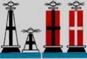
Cardinal signs
This system of navigation signs is used to indicate dangers and obstacles in the path of sea or river transport, and also shows which side to avoid the danger.
The signs are pillar-shaped, black and yellow, with two black triangles and sometimes a white light on top. The arrangement of black and yellow stripes, as well as triangles, differ depending on the type of cardinal sign.

They are set according to the principle of being away from danger depending on the cardinal directions. Thus, cardinal signs are divided into 4 types: northern (located from the north of danger), southern (from the south), western (from the west), eastern (from the east). Having seen one of them, the driver of the vessel must avoid the danger from the side of the world to which this means of navigation equipment belongs. That is, if there is a southern cardinal sign, then you need to avoid the danger from the southern side.
Special purpose signs
To highlight special areas or objects, special floating signs are used. Examples of the use of special signs: a traffic separation area, a soil dump, a cable or pipeline connection, a military zone, a training ground, the location of fishing gear, anchorages, etc.
Floating signs can be of any shape provided unified system navigation in the aquatic environment. The characteristic color of the signs of this group is yellow; a curved cross or the letter “x” is used as the top figure. If there is a signal light, a yellow light can be seen on them.

The number of signs displayed depends on the significance and area of the area or object. For a small object, one special sign is placed in the middle of the object, and if you need to highlight a fairly significant area, the arrangement of special signs is used according to the principle of tracing the perimeter.
Axial marks
Axial sign, or, as it is also called, sign clean water informs the navigator that there is a water area around the object that is safe for navigation, in other words, it marks the axis of the fairway and indicates a safe course.

The IALA navigation system includes 3 forms of axial marks: sphere, pole and cylinder. The color consists of alternating vertical stripes of red and white flowers. At the top there is a top figure - a red ball and a white flashing light.
Selected Hazard Fence Signs
To designate individual underwater objects that pose a danger to a moving vessel, floating fencing signs are used. These navigation aids mean that various kinds of obstacles are only located directly under the sign, and the surrounding water area is safe for the movement of sea and river transport. The category of individual hazards includes: remains of a sunken ship, shallow water.

The group of navigation aids is represented by columnar or conical shapes with a wide base (landmarks), black in color with one or more horizontal red stripes. The top figure is two black balls located one above the other.
Floating signs are installed in addition to coastal ones, to indicate the edges or axis of the shipping channel and fairway, as well as to indicate the locations of underwater obstacles, turns and branches of the shipping channel, and to indicate the direction of the drift current.
To the floating navigation signs relate buoys, buoys and milestones.
The design of the sign is determined by the hydrological conditions of the waterway on which it is installed. There are four types of floating sign silhouettes on inland waterways: triangular, rectangular, round and linear. Each silhouette sign, depending on its visibility range, has different dimensions of the surface part, which are regulated by the State Standard. So the height of the fire above the water level is 0.8-1.5 m for river buoys, 2-3 m for lake buoys and 3.1-6.5 m for sea buoys.
The need to install buoys with different types of signal figure silhouettes on the edges of the shipping channel is caused by the difficulty of recognizing the color of the signs under unfavorable conditions. So, when the Sun is behind the buoy at a low altitude, the distance at which the color of the buoy is recognized is 150-200 m. This distance is not enough to perform maneuvers in a timely manner, especially in conditions of a winding ship's passage. The use of buoys of different silhouettes significantly increases the distance from which they can be recognized as belonging to the right or left edge. On lake and sea buoys, top figures are used for this purpose.
Depending on the hydrological features of the installation site and operating conditions, buoys are divided into river, lake-river, lake and sea. River and lake-river buoys are adapted to work in areas where the predominant factors influencing them are static loads - current and constant wind load, while other buoys are adapted to work in areas where the main factor is the disturbance of the water surface. When installing buoys of the first group, a reduction in the roll angle under the influence of the current is provided, for the second group - a reduction in the roll angle in waves.
River and lake-river buoy(Fig. 6.21) is a metal float with a surface part that has a triangular and rectangular silhouette. At its top there is a circular signal light. In the above-water part of the buoy body in a special case
The power supply for the signal light is located. The buoy is held in place by an anchor. Buoys are the predominant type of floating mark on inland waterways.
 Sea buoy(Fig. 6.22) consists of a cylindrical body with a metal lattice superstructure and a shank with cast iron ballast. A light-optical apparatus is installed at the top of the superstructure. Ballast provides the buoy with the necessary stability. Inside the case there are hermetically sealed canisters in which electric batteries or acetylene cylinders are placed that power the light-optical apparatus. To obtain the desired fire characteristics, an electric flasher or an acetylene flasher is introduced into the buoy equipment. Passive radar reflectors are installed on lake and sea buoys, thanks to which their detection range is significantly increased.
To give sound signals in poor visibility, sea buoys are equipped with sound signaling devices: bells and air wave howlers. The action of the bell is based on the use of inertial forces that arise when the buoy rocks; the howler is driven by vertical oscillations of the buoy caused by waves.
The anchoring device of the buoys consists of an anchor chain into which a swivel is inserted, and a cast iron or concrete anchor. The length of the anchor chain is usually taken equal to double or triple the depth at the place where the buoy is placed.
Buoy(Fig. 6.23) is a floating sign consisting of a raft with a signal figure attached to it - a superstructure. The signal figure, depending on the purpose of the buoy, has a silhouette in the form of a triangle, circle or rectangle. The buoy raft and its superstructure are made of wood.

Rice. 6.23. Buoys:
a – pyramidal; b – ball; c – cylindrical
The superstructure of the triangular silhouette is a triangular pyramid. Its edges are made of bars and sheathed with thin boards with a gap of 1.5-2.0 cm. At the top of the pyramid there is a pin for installing a signal light. A shelf is arranged inside the pyramid to accommodate the lantern's power supplies. Buoys of a triangular silhouette are used for fencing, as a rule, the left edge of the ship's passage.
The superstructure of a round silhouette (ball) consists of two intersecting round board panels attached crosswise to a vertical post. The lantern is mounted on top of this post. The power supply shelf is located in the corner between the circles.
The superstructure of a rectangular silhouette (cylindrical) consists of two round rims with plank upholstery. It can also be made in the form of three planes (rectangles) intersecting at an angle of 120°, mounted on a raft.
Buoys in the form of a ball or cylinder are installed only to indicate the right edge of the navigation channel.
Typically, buoys and buoys are used only during physical navigation periods when waterways are clear of ice. During the period of spring and autumn ice drift, and on reservoirs, non-luminous cigar-shaped ice buoys are used as backup ones.
Lake and river floating milestones(Fig. 6.24, a, b) are used for fencing the shipping passage on waterways with unlit navigation equipment, and are also used for installation together with buoys and buoys as additional signs in particularly difficult areas (turns, approaches to berths, etc. .) or as control ones - for duplicating buoys and buoys.
A pole is a vertically or obliquely floating wooden pole, to the lower end of which an anchor weight is attached. The length of a lake pole reaches 10 m, and a river pole reaches 3-8 m. The upper part of the pole, protruding from the water (about 1/3 of the length), is painted in accordance with the purpose of the pole. On the milestones of the right edge and the axis of the navigation channel, the top (distinctive) figures in the form of a circle are fixed, made of two intersecting disks.
 Marine milestones(Fig. 6.24, c) are used as marine floating warning signs to fence off marine navigational hazards, mark the position of sea channels and fairways, underwater cables, and anchorages. The marine pole consists of a steel body, a metal pipe (pole), a top figure, a counterweight (ballast) and an anchor device. The length of the metal marine pole reaches 9 m.
On inland waterways, lateral, axial and cardinal floating navigation signs are used, which have their own distinctive features in terms of coloring and the nature of the signal light, depending on their purpose and placement.
Lateral floating signs indicate the edges (sides) of a shipping channel or fairway, and axial– the axis of the shipping channel or fairway.
Cardinal floating signs certain navigational hazards (shoals, banks, rocks, capes, sunken ships, etc.) on the seas and large lakes are protected. Floating signs are placed around the danger in such a way that they protect it relative to the cardinal points.
Lateral signs are divided into edge, rotary, danger signs (standing on the danger), dump, dividing, and axial– axial and rotary-axial.
Edge marks serve to mark the edges of the ship's passage. The right edge of the shipping channel is fenced with buoys or buoys of a rectangular, round or linear silhouette of red color, as well as red milestones with a topmark (Fig. 6.25, a). At night, a constant or flashing red light is lit on the right edge signs.
The left edge of the shipping channel is fenced with floating signs of a triangular or linear silhouette of white or black color(black color is used on lakes or reservoirs), as well as white milestones (Fig. 6.25, b). The signal light of buoys and buoys on the left edge is white, yellow or green, constant or flashing.
On rivers, the names of the edges (sides) of the navigation channel are taken in the direction of the flow. On transit ship passages of reservoirs, the names of the edges are taken in the direction from the zone of pinching out of the backwater to the dam. On shipping canals, the accepted name of the parties is conventional and is indicated in projects for the development of these waterways. On lakes, the names of the parties are usually taken into account the rivers flowing into and out of them and are indicated on maps.
Rotary signs are used to indicate turns in straight sections of the shipping lane that have a significant length, as well as turns in the shipping lane in areas with limited visibility and a rocky bottom. On rivers they are usually installed in steep places.  gates of the waterway, when the relief of the coastal strip does not allow you to see navigational signs located behind the bend.
A turn sign installed on the right edge (when moving down) indicates a right turn. It is a buoy of a rectangular or linear silhouette of red color with a black or white horizontal stripe in the middle (Fig. 6.25, c). The signal light of the right edge buoys is red, frequently flashing or flashing.
The left edge turn sign, indicating a left turn, is a buoy of a triangular or linear silhouette, painted white with a black horizontal stripe in the middle or black with a white horizontal stripe in the middle (Fig. 6.25, d). Signal light - green, white, yellow, frequently flashing or flashing.
Danger signs(duplicate signs) serve to designate individual, especially dangerous obstacles for navigation (hidden underwater straightening and water intake structures, single rocks, sunken ships, etc.) located near the edge of the shipping channel. These obstacles are protected by two floating signs - an edge one and a backup one (standing at the danger). The danger sign is installed directly at the fenced danger on the river side, and the edge sign is 10-15 m from it towards the axis of the navigation channel. If the edge sign is knocked down by a vessel, a duplicate sign remains, which ensures the safety of vessel traffic.
The left edge danger sign (Fig. 6.25, e) is a buoy or buoy of a triangular silhouette, painted white with a black horizontal stripe in the middle and three to four black vertical stripes, which, when intersecting, form a cross. At night, a green double-flashing or flashing light is lit on this sign.
The right edge danger sign (Fig. 6.25, e) is a red rectangular silhouette buoy with white or black horizontal and vertical stripes forming a cross when crossed. Signal light - red double flashing or flashing.
dump signs indicate sections of the waterway with strong currents that significantly impede navigation. They are installed upstream on the edge of the ship's passage, opposite the dump.
The left edge dump mark (Fig. 6.26, a) is a buoy or buoy of a triangular silhouette, the upper half of which is painted white and the lower half black. The signal light is green, group-frequently flashing or flashing.
The dumping mark of the right edge (Fig. 6.26, b) is a buoy or buoy of a rectangular silhouette, the upper half of which is painted red, and the lower half is painted white or black. Signal light - red group, frequently flashing or flashing.
 It should be noted that on a section of the waterway, a flashing light can only be used on one of the above floating signs. For example, if a flashing light is used on edge signs, then a flashing light cannot be installed on turn, dump and danger signs.
Dividing marks serve to indicate the separation of the shipping lane. The sign is a buoy of a triangular silhouette, painted with three black or white and three red alternating vertical stripes, equal to each other (Fig. 6.26, c).
The division of the navigation channel can also be indicated by two adjacent floating signs of the left and right edges of the navigation channel (paired sign) (Fig. 6.26, d).
On the dividing sign in the dark, two signal lights are lit simultaneously: red and green, red and white, or red and yellow flashing lights. On the paired dividing sign there is a signal light: on the right edge sign - red constant; on the left edge sign – green, white or yellow permanent.
Axial marks(Fig. 6.26, d) are installed along the axis of the navigation channel, dividing it into two running parts. Orientation by these signs is carried out according to the principle: “Follow from sign to sign, leaving me on the left.”
The axial buoy has a triangular or linear silhouette, painted with two black and three white, equal in width, horizontal alternating stripes. Signal light - white or yellow double flashing. The axial pole has the same color as the axial buoy.
Rotary axle signs(Fig. 6.26, e) serve to indicate the turn of the ship's passage. Buoys and milestones are used as these signs. The rotary-axial buoy has the same shape as the axial one, but its surface part is painted with two black or white and three red stripes. Signal light - white or yellow group-flash.
Floating signs are placed no later than on the third day after the waterway is cleared of ice and remain in effect until grease and slush appear.
On large lakes and sea waters Russia has adopted the floating fencing system of the International Association of Lighthouse Authorities - IALA system.
The IALA system provides for the division of the World Ocean into two regions - the region A and region B.
The IALA floating containment system is generally the same for both regions. Dividing the system into regions A And B caused only by differences in the color of the lateral marks and lights.
Russia, countries of Europe, Asia (except Japan and South Korea), Africa and Australia declared their membership in the region A. In Region A, red signs and lights are used for the left side of fairways and channels (red on the left), and green for the right side of fairways and channels.
In the region B, to which the countries of North and South America, Japan and South Korea have declared their membership, the red color is adopted for fencing the right side of fairways and channels (red on the right).
The IALA floating barrier system includes five types of signs: lateral signs; cardinal signs; small sized individual hazard signs; axial marks (signs indicating the starting points and axis of a fairway or channel and the middle of a passage); special purpose signs.
Lateral signs IALA systems are divided into fairway and channel side fencing signs and fairway separation signs.
Fairway side fencing signs(Fig. 6.27) serve to designate the sides of the fairway (channel).
On the left side of the fairways, signs are placed completely painted in red; the top figures look like a red cylinder (Fig. 6.27, a). Signal light – red flashing (period 3 s).
On the right side of the fairways there are signs painted completely green (Fig. 6.27, b). The top figure is a green cone with the top up. Signal light – green flashing (period 3 s).
Fairway separation signs(Fig. 6.28) are installed in places where the fairway divides and show the position of the main fairway (channel) relative to the posted sign, counting from the sea. The sign “Main fairway on the right” (Fig. 6.28, a) is painted red with a wide green horizontal stripe. The top figure is shaped like a red cylinder. The signal light is red, the character of the light is complex group flashing (period 9 s). The sign “Main fairway on the left” (Fig. 6.28, b) is painted green with a wide red horizontal stripe. The top figure is a cone with the apex up. The signal light is green, the character of the light is complex group flashing (period 9 s).
Cardinal signs(Fig. 6.29) are designed to protect navigational hazards. They are placed around the danger according to the principle of fencing it relative to the cardinal points (along the four main directions of the compass). In this case, the horizon around the danger is conventionally divided into four sectors: northern, eastern, southern and western. Cardinal signs are displayed in one, several or all sectors at the same time to indicate the side from which the protected danger should be avoided. The cardinal sign is called by the name of the sector in which it is located.
North sign It is black at the top and yellow at the bottom. The top figure is two cones with their vertices up. The signal light is white, frequently flashing.
Eastern sign It is black in color with a wide horizontal yellow stripe. The top figure is two black cones with their bases together. The signal light is a white flashing light of three frequent flashes (period 10 s).
South sign It is yellow at the top and black at the bottom. The top figure is two black cones with their vertices down. Light – white, six frequent flashes and one long flash, period 15 s.
Western sign It is yellow in color with a wide horizontal stripe of black. The top figure is two black cones with their vertices together. Signal light - white, nine frequent flashes, period 15 s.
Small individual hazard signs(Fig. 6.30, a) protect individual, small-sized dangers (including sunken ships), inscribed in a circle with a radius of 100 m. They are placed above the danger and can be bypassed from any side. The color of the signs is black with a wide red horizontal stripe. The top piece is two black balls one above the other. Light – white, double flashing, period 5 s.
Axial marks(Fig. 6.30, b) serve to designate the starting points and axes of fairways (channels) and the middle of passages. They are installed on the axis of fairways, recommended courses and the middle of safe passages. The signs are painted with red and white vertical stripes. The top piece is one red ball. Signal light – white long-flashing (period 6 s).
Special purpose signs(Fig. 6.30, c) are used for fencing special areas, training grounds and objects (for example, for fencing soil dumps, military training sites, cable laying, etc.). The color of the sign is yellow, the top figure is one yellow oblique cross. Signal light – yellow flashing (period 5 s).
Floating navigational marks of the lateral system
Floating navigational signs according to their purpose are divided into edge, rotary, danger, stall, dividing, axial and rotary-axial signs.
Edge signs (milestones, buoys, buoys) are used to mark the edges of the shipping channel.
All signs on the right bank are painted only in red. The right-bank landmarks have a top figure at the top - a black ball or golik (a broom made of twigs). When the vessel moves downstream, these signs are left on the right, against the current - on the left.
On the left bank, the poles and buoys are painted white; on lake-river sections of reservoirs, the buoys can be black, and the buoys are always black. Both the buoys and the left edge buoys are only conical in shape. When the vessel moves downstream, these signs are left on the left, when moving upstream, on the right.
Turning signs - indicate turns in straight sections of a shipping channel that have a significant length, as well as sharp turns in a shipping channel in sections of a waterway with limited visibility or a rocky bottom.

Turning marks are, in principle, ordinary edge marks - buoys or buoys - of a triangular or rectangular silhouette (red, white or black) with a horizontal contrasting (black or white) stripe in the middle. As a rule, they stand near a convex shore. The turning sign of the left edge shows the turn of the ship's passage to the left relative to the current; when passing through it, the vessel must turn to the left, leaving a sign to the left bank.
The turning sign on the right edge shows the turn of the ship's passage to the right relative to the current; when passing through it, the vessel must turn to the right, leaving the sign towards the right bank.
Danger signs - indicate particularly dangerous and underwater obstacles at the edges of the shipping channel (submerged structures, sunken ships, sandbanks, underwater rocks, etc.).
These signs are installed directly at the protected danger on the river side (from the current side). Where these signs are located, the boatmaster must take special precautions to prevent the vessel from approaching this sign.
The danger signs on the left edge are buoys, buoys of a triangular silhouette, white, with one black horizontal stripe in the middle and one vertical stripe.
Right edge hazard signs are buoys, buoys, rectangular silhouette red, with one black or white horizontal stripe in the middle and one black or white vertical stripe.
The main difference between danger signs by color is that the stripes on
buoys and buoys form a clearly visible cross - a danger sign.
Slipping marks indicate places where the direction of the current does not coincide with the direction of the navigation.

Dumping marks are installed near the edge marks on the edge of the shipping channel opposite the current flow, so that the line where the signs are installed shows the direction of the dumping current.
The left edge marks are a buoy or buoy of a triangular silhouette, their lower half is black, the upper half is white.
The right edge markings are a buoy or buoy of a rectangular silhouette in red, the lower half of which is black or white.
Dividing signs indicate places of division (branching) of the shipping channel.

The signs have a triangular silhouette.
They are painted with alternating vertical stripes of red and black (or white).
Instead of a dividing sign, it is allowed to use two edge (paired) signs - the left and right edges of the navigation channel.
Axle marks are installed along the axis of the navigation channel (if its width is at least 300 m), dividing it into two navigation lanes - for ships going upstream and for ships going downstream. Orientation using axle marks is carried out according to the principle - " follow from sign to sign, leaving it on the left." To indicate the axis of the navigation channel, axial buoys and milestones are used, and to indicate the turn of the navigation channel, rotary-axial buoys and milestones are used.

Axial buoys and poles have a triangular or linear silhouette, painted with two black and three white, equal in width, horizontal alternating stripes. The milestone has a round (spherical) top figure of black color at the top.
Rotary-axial buoys have the same shape as axial ones (triangular or linear). Its superstructure is painted with two black or white and three red, equal in width, horizontal alternating stripes.
The pivot pole is painted with two black or white and three red, horizontal alternating stripes. The top figure of the milestone is a black ball.
Using these signs, the navigator determines the direction of the navigation.
These include: axial, slot and edge sashes; pass, running and spring signs; "Landmark" sign; track light.
Axial alignment Consists of two signs (front and rear), indicating the axis of the navigation channel on the straight-line section of the waterway. Sometimes this alignment is called linear.
The front sign is located below the rear one. According to their shape, axial alignment signs can be of three types: rectangular (square) panels; trapezoidal panels; combined (lower shield is trapezoidal, upper shield is square).
The color of the shields is chosen depending on the background of the surrounding area. Red shields with a white or black vertical stripe in the middle are displayed on a light background, and white shields with a black stripe on a dark background. In cases where signs are displayed against the sky, they may be black with white stripes.
At night, a white or green constant light is on the front sign, and a white or green flashing light is on the rear sign.
When following the axis of the navigation channel, the navigator observes combined guide strips of signs (during the day) and lights (at night), located on the same vertical. If the vessel deviates from its axis, the signs shift relative to each other or the conventional line connecting the lights tilts.
The gate is slotted. Indicates the direction and edges of the navigation channel. Consists of two front and one rear rectangular shields.
Red shields with white or black stripes are installed on a light background, white shields with black stripes on a dark background, and black shields with white stripes against the sky.
The front lights are white constant, the rear lights are white flashing. On the left bank, the front signs may be equipped with constant green lights, the rear ones with flashing green lights, and on the right bank - the front constant red lights, the rear ones with flashing red lights.
If the navigator observes the rear shield (light) between the front ones, then the ship is on the channel; if the strip of one of the front shields coincides with the strip of the rear shield, then this means that the ship has reached the edge of the channel.
Edge section. Indicates the exact direction of the boundaries - the edges of the navigation channel.
The edge panels are painted depending on the background of the area: on a dark background - white, on a light background - red.
The lights on the left edge are green, front constant, rear double flashing; on the right edge the lights are red, the front is constant, the rear is double-flashing.
In fact, this alignment can be considered as two combined axial alignments, one of which shows the left edge of the shipping channel, and the other - the right.
As long as the navigator observes during the day the clearance between the vertical edges of the shields of the front and rear signs (at night, the conventional line connecting the lights of these signs is inclined towards the shipping lane), the vessel is in the directional zone.
Two positions of the vessel when orienting along the edge alignment:
a) the vessel is on the left edge of the channel, because the vertical edges of the front and rear signs are combined;
b) the ship is on the axis of the navigation channel.
Pass sign serves to designate a ship's passage and is installed in places where this passage changes direction from one shore to another. Unlike cross-country crossings, pass signs are placed one at a time.
The shape of pass signs can be:
A pillar with two square shields attached to its top, indicating two directions of navigation;
Rectangular vertical boards the full height of the sign, installed so that their front sides indicate the directions of the navigation;
The third type of pass sign is a structure of inclined trapezoidal shields tapering upward with square shields at their tops.
On a light background, shields are painted red, on a dark background - white. Vertical stripes are not applied to shields.
Signs on the left bank are equipped with a constant green light, while those on the right bank are equipped with a constant red light. It is possible to equip the signs on both banks with white flashing lights.
The number of pass signs displayed on a section of the river depends on the tortuosity of the navigation channel. At passes there are usually two signs posted - a sign on the left and right banks. Moreover, if these signs are connected by a conventional straight line, then it will coincide with the axis of the navigation channel.
running sign. Serves to designate a ship's passage passing in close proximity to the shore.
The sign consists of a pillar and a diamond-shaped shield attached to its top. To increase the visibility range, the shield can be set to the full height of the sign.
Most often this sign is located on clean (running) ravines.
The color of the sign board on the right bank is red, on the left - white.
The navigation signs on the left bank are equipped with green flashing lights of all-round visibility, and those on the right bank are equipped with the same red lights.
Spring sign It is used to indicate flooded shores and is displayed on flooded islands, ravines, and capes to prevent the ship from running aground.
On the left bank, the sign is a structure made of a pillar, on top of which a white trapezoidal shield is fixed.
On the right bank there is a round red shield of the spring sign.
The spring sign of the left bank is equipped with a constant green light, the right bank - with a constant red light -
Landmark sign " Used to designate characteristic noticeable places (cape, island, etc.) on rivers, reservoirs and lakes.
The sign has a rectangular or trapezoidal shape. The shields (sloping) on the left bank are painted with alternating stripes of horizontal black and white, and on the right bank - red and white.
The left bank signs are equipped with a green two-flashing light, and the right bank signs are equipped with a red two-flashing light. It is possible to use two-flashing white lights on signs on both banks.
Track light. It is installed on the slopes of the banks of shipping canals and serves to orient navigators.
Track lights are placed on both sides of the canal in pairs (opposite each other), usually every 250 m. The sign, as a rule, is a one-meter arbitrary structure painted with ball paint.
At night, at the top of the sign, a green constant light is lit on the left bank, and a red constant light is lit on the right bank. These lights are directed along the canal. In addition, the sign may have a lower white light, which is covered by a canopy on top and illuminates the slope of the canal and the water's edge.
Identification mark Designed to mark the entrance to the canal from the side of the river, reservoir and lake. It is usually a tower of various designs.
Signs and lights on bridges. These signs indicate the spans for the passage of ships, rafters and small watercraft under the bridges from above and below, as well as the direction of the axis of the ship's passage and the height of the under-bridge clearances. A visual appearance and characteristics of signs and lights displayed on bridges is presented
Navigable spans of bridges are indicated by the following signs and lights located on the trusses in the middle of these spans:
a) for ships coming from below - a square shield, at night - two constant red leading lights, visible from the running side of the span;
b) for ships coming from above - a diamond-shaped shield, at night - two constant red leading lights, visible from the running side of the span;
c) for raft trains - round shield, at night - two constant green directional lights;
d) for small vessels - a triangular shield, with the top down, lights are not displayed at night. On a dark background, the signs are painted white, on a light background - red.
Under-bridge height indicators are square panels (green on a light background or white on a dark background), located vertically one above the other on bridge supports. At night, a green, constant fire burns in the center of each shield.
Lights on floating bridges
The floating bridge, when it is raised, must have the following light signaling in the dark to allow ships to pass through:
on the right downstream side of the span - two red constant lights (at the downstream and upstream corners of the span);
on the left side of the span - two green constant lights (at the lower and upper corners of the span);
on the allocated part of the bridge, at the end protruding into the river, a signal light corresponding to the edge ones is installed on the core side (red to the right bank, green to the left);
on the erected bridge, white lights are installed along its entire length every 50 m at a height of at least 2 m above the upper deck of the bridge.
Regulation of the passage of vessels through the spread parts of the floating bridge is carried out using signals raised on the semaphore mast
Lighthouses serve to guide navigators when navigating at some estuary sections of large rivers, reservoirs, lakes, as well as the entrance to the canal.
They are towers of various designs and architectures (Fig. 168).
At the top of the lighthouse there is equipment for supplying light signals with the established characteristics and color of the fire. Some beacons are equipped with fog sound alarms, as well as radio equipment for sending radio signals at certain frequencies.
The description of the lighthouses is set out in detail in the corresponding directions, and their exact coordinates (latitude and longitude) of location are plotted on navigation maps.
Schemes for placing navigation signs. To consolidate knowledge of navigational signs and acquire primary skills in orienting by them while sailing, it is useful for a novice navigator to learn to read maps (diagrams) of sections of the route with navigational landmarks marked on them.
The simplest diagrams for placing the most common signs indicating the axis of the navigation route, which is marked with a dotted line, are shown in Fig. 169-172.
Linear target is the most common alignment installed on waterways, and gives the exact position of the axis of the navigation channel.
Slot and edge sashes They are used mainly in areas where it is necessary to ensure increased reliability of the situation, improve the orientation of navigators when passing and overtaking, as well as in places where floating signs are often knocked out of their regular places.
Pass signs (1, 2, 3. 4, 5, 6) are usually installed on the deep banks of reaches and pass sections of rivers, as well as on waterways with unlit and reflective conditions.
Navigation signs (7,8) are installed to ensure the movement of vessels from sign to sign, as well as between directional and cross-over signs.
Spring signs are installed on capes protruding towards the shipping lane and on the edges of floodplain banks. On rice. 177 spring signs indicate dangerous flooded edges of the banks. Signs 1 and 3 - right bank. 2 and 4 - left.
The information signs shown on the color tab (application) are divided into three groups.